Uploaded by Background Pony #B858
1280x2006 PNG 3.91 MB
Interested in advertising on Derpibooru? Click here for information!

Help fund the $15 daily operational cost of Derpibooru - support us financially!
Description
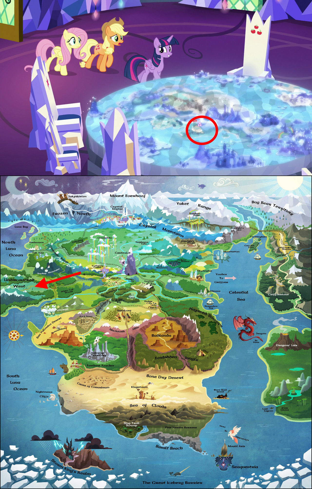
The map got me turned around, but this seems the most likely spot.
Tags
+-SH safe2174482 +-SH edit173008 +-SH edited screencap90467 +-SH screencap295747 +-SH applejack200489 +-SH fluttershy258617 +-SH twilight sparkle357768 +-SH alicorn314147 +-SH classical hippogriff6404 +-SH dragon85417 +-SH earth pony446398 +-SH hippogriff13546 +-SH narwhal81 +-SH pegasus496551 +-SH pony1602639 +-SH g42028975 +-SH my little pony: the movie21438 +-SH rainbow falls1891 +-SH sounds of silence3513 +-SH abyssinia20 +-SH airship1210 +-SH appleloosa336 +-SH arimaspi territory22 +-SH badlands72 +-SH baltimare72 +-SH basalt beach44 +-SH black skull island25 +-SH bone dry desert74 +-SH bugbear territory10 +-SH canterlot7156 +-SH caves of conundrum4 +-SH celestial sea12 +-SH circled78 +-SH cloudsdale1598 +-SH crystal empire2863 +-SH crystal mountains15 +-SH cutie map929 +-SH desert2138 +-SH dodge city19 +-SH equestria640 +-SH everfree forest2579 +-SH farthest reaches6 +-SH forbidden jungle9 +-SH friendship throne743 +-SH froggy bottom bog73 +-SH frozen north48 +-SH galloping gorge7 +-SH generic pony871 +-SH ghastly gorge109 +-SH great iceberg barrier9 +-SH griffish isles30 +-SH griffonstone321 +-SH guto river3 +-SH hayseed swamp29 +-SH hollow shades30 +-SH horseshoe bay17 +-SH kirin grove11 +-SH klugetown282 +-SH las pegasus189 +-SH los pegasus22 +-SH lost lagoon8 +-SH luna bay5 +-SH macintosh hills6 +-SH manehattan1265 +-SH map1840 +-SH map of equestria320 +-SH mount aris265 +-SH mount everhoof46 +-SH neighagra falls43 +-SH nightmare cliffs6 +-SH north luna ocean5 +-SH our town400 +-SH parts unknown4 +-SH peaks of peril34 +-SH pine needle barrens15 +-SH ponyville7848 +-SH rock farm665 +-SH saddle lake9 +-SH san palomino desert10 +-SH sea of clouds20 +-SH seaquestria1061 +-SH slug troll swamp13 +-SH smokey mountains24 +-SH somnambula (location)178 +-SH south luna ocean6 +-SH starlight's village78 +-SH storm king's castle5 +-SH storm king's realm11 +-SH tall tale18 +-SH trottingham48 +-SH twilight sparkle (alicorn)149131 +-SH twilight's castle5548 +-SH undiscovered west7 +-SH unicorn range12 +-SH vanhoover48 +-SH vector89886 +-SH wall of tags6647 +-SH whitetail woods52 +-SH world map61 +-SH yaket range15 +-SH yakyakistan181
Source
not provided yet
Loading...
Loading...
Well, I guess so. Except that is missing the Hippogriff Continent and the kingdom of Abyssinia.
where is that newer map?
The Cutie Map is closest at things like continents’ shape, IMHO, just because it is information directly from the show. But these places with Pillars’ relics look like heresy. At least, Mistmane’s location makes me sad.
easy there are a few but here are my top pics 1. needing to use up the money to keep the budget
It was common in the wild wast times and now when the gorvment body give a budget they want you to use every last cent or they will cut it, so what i think happen is that they just put train tracks there just to keep the budget they have and just call it a day.
to this day you will still find train tracks in the middel of no where that no one have tought to look for in the wild, like the wood lands, motions and many other areas lots of them got abounded after they fill there role in keeping the budget on paper.
2 the loop ring.
what i think is that they wanted to build train tracks that loop around the smokey mountains given las pegas is right there and would make logical sesen they wanted to build a rail lane to the city of vanhoover.
given that vanhoover is a part city i can see that they wanted easy way and cheaper way to trade goods with each other a common thing in real ife like how the UK and france work side by side to build an underground tunnle to link the two so trade can be easy and fast.
This show sure hates ships.
Edited
Cannon???
No, no, the Cutie Map is a table, not a piece of heavy artillery.
I can’t believe I didn’t notice that.
I presume so
@Victor_van_Claw
That’s fair enough, though I’m wondering what would be closest to the canonical map? Do you have a link to one on here?
@Frustration in Excelsis
Bronies. Stop using this stupid merchandise map. This map is all wrong for long time. When movie come out, they added new territories without fixing map.
Only Cutie Mark Map is cannon.
Hasbro have removed all official maps from there sites, last one they showed was from 2015.

your current filter.Wouldn’t be the first time the map flipped something.
There’s also no train that runs anywhere near there. You do know it’s entirely possible for Kirin to live in more than one place, right?
Worse, the in-show map is actually wrong, and there’s a newer version of the official map that puts the Kirin village over near the volcano to the east.
If that’s right, than the I believe the Perilous Peaks are the sharp looking mountains between the Badlands and the Hayseed Swamp.
Edited